Campsite MÜLLERWIESE
Hiking tours in the northern Black Forest

Holiday Resort Enzklösterle
Use the campsite Müllerwiese as starting point for many short or long hiking tours through the environs of Enzklösterle.
Here you will have the opportunity to walk on hundreds of kilometers well signposted hiking trails and to discover the largest woodland of the northern Black Forest.
On your hiking tours stop over at the primeval forest of Bärlochkar, the big sphagnum bog at Kaltenbronn or the Red Deer park.
Visit the bio information center at Kaltenbronn or the new Wild Line suspension bridge as well as the tree top path and the funicular railway at Bad Wildbad and the Poppel valley toboggan run.
At Enzklösterle you can take part in guided walking tours and at Kaltenbronn in nature studies offered by the bio information center.

Wild Line Suspension Bridge at Bad Wildbad (12 km)
HIKING TOURS and GPS-TRACKS
In the following you will find a small part of the wide range of possible hiking tours with starting point campsite Müllerwiese.
Some of the tours can be downloaded as GPS-Tracks for GPS-navigators.
- Enz promenade. Start at the campsite Müllerwiese and walk along the river Enz up the valley. The sunny path offers many sites to relax nearby the clear spring water while taking the sounds of nature. The Enz promenade ends at the Rohnbachtalstrasse. Distance there and back: 3 km; course 1 hour

View from mount Schöllkopf over the Blueberry Village Enzklösterle
- Short Enzklösterle walk. Start at campsite Müllerwiese - walk up the Gernsbacher Steige - turn right and follow the path at the edge of the forest around the mount Schneckenkopf - take the Schneckentalweg down to the main road and cross the river Enz - walk up to the edge of the forest at mount Schöllkopf and follow the panoramic path to the Schöllkopfsteige - then turn down to the village and cross the main road - take the way back to the campsite through the spa gardens of Enzklösterle. Distance covered 3,5 km; course 1 hour; elevation 105 m.See, print and download GPS-track in alltrails - Kleine Enzklösterle Tour
- Medium Enzklösterle walk. Start at campsite Müllerwiese, walk to the spa gardens an visit the "Kneipp"-water-pool and the barefoot path - then take the Kirchweg to Gernsbacher Steige and further up to the romantic path along the Schneckenkopf, down to the red deer park - walk up the path to the Erdbeerplatte (strawberry place) - after a little rest at the blueberry swing with scenic view go down to the Enz valley to the historic building "Russhütte" (soot hut) - follow the Bergweg along the wood for 500 m, turn left and take the narrow path to the river Rohnbach, behind the bridge turn to left again and follow Rohnbachstr. to reach the show raft - cross the bridge over river Enz, turn left and follow the Enzpromenade back to Camping Müllerwiese. Distance covered 6,6 km; course 2 hours; elevation 160 m. See, print and download GPS-track in www.outdooractive.com

View from mount "Hirschkopf" on the long Enzklösterle walk
- Long Enzklösterle walk. Start at campsite Müllerwiese - cross the bridge over the Enz nearby the campsite - old hotel Hetschelhof - main road (Freudenstädter Strasse) - Rathausweg - at the edge of the forest turn left and walk along the forest edge on the panoramic path - cross the road to Simmersfeld and continue the walk down into the Lappach valley - at the edge of the forest cross the little brook and go back towards the village - take the panoramic path along the forest edge at the mount Schöllkopf (direction Nonnenmiss) - walk down to the Enz and cross the main road (Wildbader Strasse) - follow a narrow path up into the Schneckental - turn to the left and walk on the panoramic path along the forest edge at the mount Schneckenkopf - cross the Gernsbacher Steige and reach the red deer park at the Hirschtal (deer valley) - walk around the park - pass the ski run and go up to the lookout point Erdbeerplatte with its blueberry swing - then take the path through the forest down into the Enz valley and return to camping Müllerwiese on the Enz promenade. Distance covered 9,5 km; course 2 - 2,5 hours; elevation 313 m. See, print and download GPS-track in alltrails - Grosse Enzklösterle Tour

Primeval Forest and nature reserve "Bärlochkar" nearby Enzklösterle
- Primeval Forest of Bärlochkar. Start at campsite Müllerwiese - cross the bridge over the Enz nearby the campsite - walk around old hotel Hetschelhof and turn back to the river Enz - follow the Enz promenade to the sports grounds - start the walk to the primeval forest at the car park above the sports grounds at the edge of the forest - follow the signposted Bärloch path. There you will be taught about the flora and fauna of the "primeval forest of tomorrow". Learn interesting facts about the geological formation of cirques by Black Forest glaciers of former ice ages - Take the Bergweg above the river Enz and return to campsite Müllerwiese. Distance covered 7,5 km; course 2 hours; elevation 218 m. See, print and download GPS-track in alltrails - Urwalderlebnis "Bärlochkar"


Minipark for children at Poppeltal and source of the river Enz at Gompelscheuer
- To the Source of the River Enz. Start at campsite Müllerwiese - bridge over the Enz nearby the campsite - old hotel Hetschelhof - Enzpromenade (promenade nearby river Enz) - Bärlochkar - Gompelscheuer - the source of the river Enz is situated within the center of the little village (now you can continue your walk either to the minipark for children, the giant toboggan run and the Poppeltal experience museum at Enzklösterle-Poppeltal or to the historic water reservoir of the Black Forest timber floaters "Kaltenbachsee", a little lake within the forest nearby Gompelscheuer). From the Enz source the path leads us further through the valley Kaltenbachtal and to the highest point of the walk with 865 m nearby the point Saubusch. Then we go back through the valley of the mountain brook Süssbächle. We cross the river Rohnbach and go over the trail Bergweg along the woods back to camping Müllerwiese. Distance covered 14 km; course 3-4 hours; elevation 340 m. See, print and download GPS-track in alltrails: Enzklösterle - Gompelscheuer - Rohnbachtal - Enzklösterle

Lakes Hohloh and Wildsee nature reserves
- To lake Hohloh and Emperor-Wilhelm-Tower. Start at campsite Müllerwiese - Hirschtalweg - Rindenhütte - G.A.Volzweg - Diebstichweg - Kaltenbronn (nature information center of the Black Forest nature park with museum and red deer park as well as the recommended restaurant Sarbacher) - Torfweg - Emperor-Wilhelm-Tower (1017 m) offers a fascinating view of the Rhine valley, the Vosges, the Northern Black Forest, the Swabian Jura and with high visibility even of the Alps - Hohloh moor, part of the largest sphagnum bog in Germany with unique flora and fauna (expert forest trips in summer season) - Schwabenweg - Diebstichweg - Viereichenhütte - Gernsbacher Steige - Enzklösterle - campsite Müllerwiese. Distance covered 16,8 km; course 4,5 - 5 hours; elevation 620 m. See, print and download GPS-track in alltrails - Zum Hohlohsee und Kaiser-Wilhelm-Turm

On the Emperor-Wilhelm-Tower: View of the northern Black Forest mountains
- Enzklösterle - Hohloh - Rohnbach valley. Start at campsite Müllerwiese - Hirschtalweg - Gernsbacher Steige - Viereichensattel with Viereichen hut - Diebstichweg - Schwabenweg - nature reserve Lake Hohloh - Emperor-Wilhelm-Tower - Alte Weinstrasse - Torfweg - Hirschbrunnen hut within the Rohnbach valley - Rombachhof - Rohnbachtalstrasse - Bergweg - campsite Müllerwiese. Distance covered 20 km; course 5 - 6 hours; elevation 420 m.
See, print and download GPS-track in alltrails - Enzklösterle - Hohloh - Rohnbach valley

At the Hohloh tower (8 km from the Müllerwiese)

Walk to Aichelberg: view of mount Schöllkopf and the Lappach valley
- Walk to Aichelberg. Start at campsite Müllerwiese - go down to the main road - pass the hotel Hirsch and the bakery - turn to the right side and walk up the Schöllkopfsteige to the Herzogsbank - from there follow the signs to the little village Aichelberg. After a break the way back leads again to the Herzogsbank but then down on a zigzag descent on mount Schöllkopf to the river Enz and the Kirchweg back to the campsite. Course there and back 3-4 hours; distance covered 13 km; elevation 340 m. See, print and download GPS-track in www.outdooractive.com
")
Neighbouring village Simmersfeld (7 km)
- Enzklösterle - Simmersfeld - Enzklösterle. Starting point Black Forest campsite Müllerwiese (altitude 600 m) - river Enz - Hetschelhof - crossing main road - Rathausweg - edge of the forest - walk the signposted path to the village Simmersfeld passing the plane on the mount Hummelberg, the road Enzklösterle to Simmersfeld and the national road B 294 - at Simmersfeld you can eat at a restaurant. On the way back to Enzklösterle you walk through the woods to the crossing of the national road B 294 and the road between Enzklösterle and Simmersfeld - turn to the left hand side and take the "Petersweg" down the hill to the little village Gompelscheuer and back to Enzklösterle-Rohnbach. Cross the little mountain brook Rohnbach before it flows into the river Enz and walk back to the campsite Müllerwiese using the so called Bergweg on the left mountain side of river Enz. If you would like to shorten the hike a little bit you can easily ride the bus from Gompelscheuer back to Enzklösterle (5 km), bus station Hetschelhof nearby the campsite but do not forget the time table. Distance covered 21 km; course 5,5 - 6 hours; elevation 520 m.See, print and download GPS-track in alltrails - Enzklösterle - Simmersfeld - Enzklösterle

Holiday resort Enzklösterle, view from mount Hirschkopf
- On very small trails: Enzkloesterle - Hirschkopf - Dietersberg. Starting point Camping Muellerwiese, Enzklösterle, Black Forest - Bergweg - Erdbeerplatte - old Ski run of Enzkloesterle - mount Hirschkopf (panoramic view on Enzklösterle) - new Ski run - Gernsbacher Steige - mount Dietersberg - Saubusch - mountainbrook Dietersbach - downhill to Nonnenmiss - Enzklösterle - mount Schneckenkopf - Black Forest Campsite Müllerwiese. Distance covered 10 km; course 2,5 - 3 hours; elevation 480 m. See, print and download GPS-track in GPS-tour.info: Enzklösterle - Hirschkopf - Dietersberg

View over Gompelscheuer, part of Enzklösterle
- Raft Walk of Jockele. The signposted theme trail for Black Forest rafters history starts 400m away from the campsite Müllerwiese in the spa gardens of Enzklösterle near the spa gardens lake. The trail leads over the "Bergweg" above the Enz-valley into the Rohnbach-valley where a small open-air museum informs about old Black Forest professions. The trail continues via Gompelscheuer to the first rafter lake, the Kaltenbachsee. Back via Gompelscheuer the trail climbs to the highest-lying part of Enzkloesterle, to Poppeltal where the restaurant Poppelmühle and the summer toboggan run invite you to visit. A short climb nearby the brook Poppelbach finally leads to the lake Poppelsee, the second restored rafter lake of Enzklösterle. A trail leads above Poppeltal and Gompelscheuer again back to the Enz-valley. On the beautiful Enzpromenade the trail leads back to the local center of Enzklösterle and to the starting point in the spa gardens. Those who get tired feet can ride the bus from Poppeltal back to Enzklösterle (free of charge with your Black Forest guest card). There are restaurants in Poppeltal and Enzklösterle for those who on the way get hungry. Distance covered 23,4 km; course 6-8 hours; elevation 690 m. See, print and download GPS-track in www.outdooractive.com

At the viewpoint of the Premium Blueberry Trail on mount Schöllkopf
- Blueberry Premium Circular Trail. Starting point of the path is the Tourist Information nearby. From there, the well signposted hiking trail leads to the Schöllkopf plateau (about 800 m altitude). There, the hiker enjoys a wonderful view of the blueberry village Enzklösterle and the valley of the river Enz on an observation deck. After a descent on mediterranean-looking paths through a pine forest, the tour continues through the idyllic and romantic valley of the Lappach brook up to mount Hummelberg. Via the Rathausweg the path leads down to the Enz and the Enz promenade and up to the "Erdbeerplatte" (strawberry plate) on mount Hirschkopf. On the blueberry swing which is installed there you will have a breathtaking view over the resort Enzklösterle. Passing the red deer enclosure you'll reach the panorama trail at the forest edge of mount Schneckenenkopf. From there we descend again down to the village to the starting point. Numerous information boards inform about all kinds of interesting facts about the blueberry. Distance covered 12,7 km; course 4 hours; elevation 374 m. See, print and download GPS-track in www.outdooractive.com.
Flyer Blueberry Path

Historic water reservoir of the Black Forest timber floaters "Kaltenbachsee"
- Schramberg Tour. Start at campsite Müllerwiese - Enz promenade - Rohnbachtalstrasse - path of the Bärlochkar - hiking trail to Gompelscheuer - Kaltenbachweg - Kaltenbachsee - Neuhaus hut - Alte Weinstrasse - Redoute - Schramberg - Hirschlachweg - Zwickgabel - Süssbächle valley - Rohnbach valley - Enz promenade - campsite Müllerwiese. Distance covered 22,5 km; course 6 hours; elevation 500 m. See, print and download GPS-track in alltrails.com - Rohnbach.

At mount Hummelberg, view of Enzklösterle and mount Schneckenkopf
- Hummelberg Tour. Campsite Müllerwiese - old hotel Hetschelhof - cross the Freudenstädter Strasse (main road) - Rathausweg - drinking water reservoir - turn to the left side - Enzsteige - walk 200 m up the street to Simmersfeld - then turn to the right side and climb up onto the mount Hummelberg - televisiontower - Italienerweg - down to the road Enzklösterle-Gompelscheuer - turn to the right side and walk above the road and the houses back to the drinking water reservoir - Rathausweg - campsite Müllerwiese. Distance covered 8,8 km; course 2 - 2,5 hours; elevation 278 m. See, print and download GPS-track in alltrails - Hummelberg Tour
- Mount Dietersberg and Mount Hirschkopf. Starting point campsite Müllerwiese - tourist information - spa gardens - protestant church - walk up the Jägerweg and the path up to the edge of the forest - crossing the Schneckentalweg - walk around the Mount Dietersberg direction Nonnenmiss - climb up the Mount Dietersberg along the Dietersbach - Mount Dietersberg hut - cross the Gernsbachersteige direction Viereichenhuette and Rohnbachvalley - after a few hundred meters turn to the left hand side and follow a panoramic path on the Mount Hirschkopf along the slopes of the Hirschvalley, Rohnbachvalley and Enzvalley. Finally descend to the Hirschvalley passing the old and new skiing slope and the viewpoint Erdbeerplatte. Return to the campsite on the Hirschtalstrasse. Distance covered 15 km; course 4 hours; elevation 435 m. See, print and download GPS-track in alltours - Dietersberg

View from Mount Dietersberg down to the Enz Valley
- Enzklösterle - forest restaurant hut "Grünhütte" - Enzklösterle. Starting point campsite Müllerwiese - tourist information - spa gardens - protestant church - walk up the Jägerweg and the path up to the edge of the forest - crossing the Schneckentalweg - walk around the Mount Dietersberg to Nonnenmiss - take the sign-posted path to the village Sprollenhaus - Wannenschleifweg - restaurant Grünhütte (altitude 867 m) where you can eat and drink traditional Black Forest dishes - Schäferweghütte - Wannenebene - down into the Enz valley through the Wildbader Teich along the small mountain brook Aiterbächle - Sprollenhaus - along the edge of the forest to Christophshof - campsite Kälbermühle - crossing the Black Forest river Enz and reaching the Enztraufweg - walk up the Enz valley on the Enztraufweg passing the Sprollenmühle with the sawmill, then the little village Nonnenmiss and along the mount Schöllkopf you will reach again Enzklösterle - back to the campsite Müllerwiese through the center of our village. The hiking tour can be shortened by using the bus (free of charge with the guest card!) from Enzklösterle to Sprollenhaus or from Christophshof back to Enzklösterle.
Distance covered 21,5 km; course 5,5 - 6 hours; elevation 590 m. See, print and download GPS-track in alltours - Enzklösterle - Grünhütte - Enzklösterle

Forest Restaurant Gruenhütte, 867 m altitude
Further GPS hiking tours with starting point nearby campsite Müllerwiese
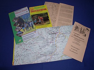
Hiking maps are available at the reception office of campsite Müllerwiese or at the tourist office (200 m).
Hiking Brochure to download
Hiking in the upper Enz valley with 14 tour suggestions
 1 / 2019
Imprint / Data protection


